
The impetus for this trip was Mark Hayden’s interest is flying out to visit his son in Durango in southwestern Colorado. I was tagging along, in a supporting role. We got underway on Saturday, September 3rd, he from his back yard in North Monmouth and I from Norridgewock. He had taken off light on fuel, so we met up at the Fryeburg airport. He got there first. I barely got in by spotting one end of the runway in the developing fog bank. It took an hour for the fog to dissipate enough to take off; not a great start. Next stop was Glens Falls, NY. This is an important milestone, since at this point, the White Mountains and Green Mountains were behind us. Progress from here was pretty good, with a slight tail wind. We skipped one of his planned stops, and pushed on to Bradford County, PA. It was a pleasant little airport with picnic tables, so we had a lunch time snack, in addition to getting gas. I talked him into making the next stop at Barber Field in Alliance, OH. There I could fill up with 93 octane auto gas, and it was also a good place to camp; actually better than I expected. There was a house trailer which had been an EAA club house, and Forrest Barber invited us to make ourselves at home. We lounged the end of the afternoon away on the attached porch, and slept on the floor inside come nightfall. Life is good!
Mark hadn’t been able to get any 100LL at Barber, as the jump club on the field owned the gas. So the next morning we stopped at Millersburg, the first airport we came to. And wouldn’t you know it, the pumps weren’t credit card capable, and being Sunday on Labor Day Weekend, there was nobody home. Mark called the manager, and eventually his daughter came out and turned on the pumps, but a good part of the morning was wasted. The next stop was Greenwood on the outskirts of Indianapolis. We had to push our planes off the edge of the ramp, so a Citation could taxi out. The wind was picking up. Rather than taxi downhill with the wind on my tail (never a good thing with weak mechanical brakes), I taxied straight out from the ramp, across the taxiway, and took off from the grass between the taxiway and runway.
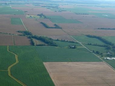
Centralia, Illinois turned out to be very busy. The place is full of young Chinese taking basic training in Cessna 150’s, on a career path to becoming airline pilots back in China. They were all dressed in airline regulation black pants and white shirts. Everything in the terminal was labeled in English and Sanskrit. Nobody really knew how to process a credit card, so if you wanted to get out of there before sundown, you were better off to pay cash for gas. All the corn fields in Illinois were dead and brown from drought, so I don’t know where our ethanol is going to come from.
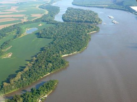
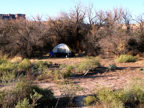
The fields turned into wooded hills; then we crossed the Mississippi River. Daylight was just about gone when we got into Lebanon, MO. The lounge was locked up, and everybody was gone. We pitched our tents next to a small building which hid us from the road, cooked up supper and sacked out. We were relieved that we weren’t arrested for vagrancy when people showed up the next morning.
The next leg of our trip took us to Bartlesville, OK. Now it was getting hot, up in the nineties. As we proceeded southwest across Oklahoma, the south wind picked up and it got bumpy. On the way to Clinton, OK, I got up to 9700 feet, trying to stay above the broken clouds in smoother air. Then I crossed a line of latitude on my tablet into total blackness. I had sailed off the edge of the earth. Actually what had happened is that I hadn’t downloaded the Dallas-Ft. Worth sectional. The course line was still there, but no terrain depiction. In addition by now my carburetor heat control was frozen.
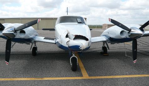
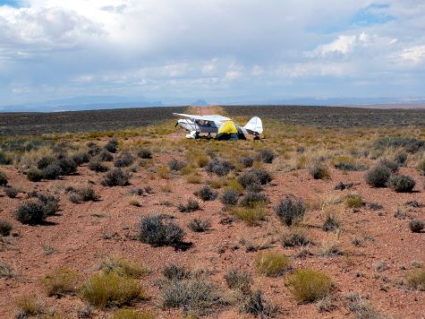
In spite of the gusty wind, I managed to make a gentle landing at Clinton. As I taxied in to the ramp a gust of wind whipped my tail around and directed me into the nose of the most expensive plane on the ramp, a three-year-old Piper Seneca. I had broken the golden rule, and attempted to taxi downwind. My nose bowl was bashed in, and my propeller was slightly bent. But that’s minor considering what I did to the other plane. And of course there was radar up there in the nose. If there ever was a scenario that qualified for being up shit creek, this was it. I was a long way from home, and I really didn’t want the FAA poking into my airplane.
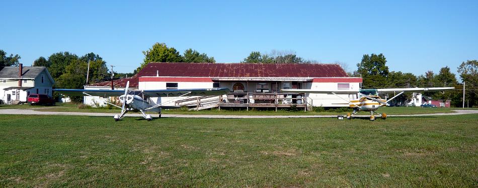
Now it’s going to take a while to explain what developed, so stay with me. The Seneca owner had flown in from Tulsa for the funeral of an uncle. It took awhile for him to get free from those ceremonies and get out to the airport. He was most gracious; his biggest concern was that no one was injured. Other members of the funeral party had come in a big Suburban, so they had plenty of room to take him back to Tulsa. Later he contacted the FAA; they called it an incident and weren’t at all interested. Break #1. The airport has two retired Crown Vic police cruisers for courtesy cars. Mark and I had unlimited use of one of them. We repaired to the Day’s Inn downtown, after pushing both our planes into empty T-hangers.
Early the next morning a retired duster pilot with tools magically appeared at the airport. We took my propeller off. I started calling prop shops. The first one I called, in eastern Oklahoma, couldn’t get to it for two weeks, and then would have to do a complete overhaul. The next one I called was about 80 miles away, just this side of Oklahoma City, but the owner just happened to be there in Clinton at that moment to pick up a pair of junk three-blade propeller assemblies. He showed up at the airport in about a half hour, and took my prop back with him. With that done, Griff the duster pilot pulled the Air Tractor out of his hanger, then Tracey the airport manager, her helper Duane, Mark and I towed my plane across the hanger complex and put it in the back of Griff’s hanger behind the Air Tractor. Then we put the Seneca in the T-hanger I had vacated. Good day’s work. Mark and I hit the Subway in Clinton for supper, toured the Route 66 museum across the street, and went back to the motel.
After the free breakfast at the motel, it was down to serious work back in Griff’s hanger. Mark, bless him, stayed around to help. Then again, the gusty winds continued, and the temperature was in the mid 90’s. It was like an oven in the back of the hanger. I had to go outside occasionally to dry off in the wind. But we scrounged around for assorted tools, blocks of wood and steel, and hammers, and pounded my nose bowl back into shape. I removed the heat box, straightened that, and freed up the flapper. We got the carb heat pull control broken loose and greased it up so it worked freely. We tightened up the right brake shoes to give me better control on the ground. After a struggle, we got the cowling buttoned up. In the afternoon a local pilot who had driven to Oklahoma City for his wife’s doctor appointment, picked up my propeller on his way back, and delivered it to the airport. Break #2: Marvin at M&M Propeller said it was only a ten minute straightening job and didn’t charge me for it. Incredible!
There wasn’t room enough between my nose and the tail of the Air Tractor to put the propeller back on, so we waited around the next day for Griff to come out and haul out his plane so I could get mine out. After we bolted the prop back on, and reinstalled the right wheel pant, I was good to go for the next day.
The next morning we were now at September 9th. It was bright and clear with light wind. Coyotes yipped in the distance. We loaded up all our gear, filled up with gas, and were on our way again. After a quick gas stop in Pampa, TX, we continued on to Santa Rosa, NM, where it was hot, and the wind was picking up. It was only mid-afternoon, but the unattended, air conditioned pilot lounge was just too inviting. We feasted and recharged our tablets. I got the couch and Mark got the couch back cushions, and we spent the night in comfort.
We were now down to just two more legs to Durango. We continued west in the morning, over more windmill farms, flat prairie, salt pans, and a 7000 foot pass into Mid Valley Airport in Los Lunas, NM. From there it was a short flight, passing west of Albuquerque, and over a final ridge into the huge airport at Durango. I made a right base entry and turned off at the first taxi way. The day was still young, and I was considering continuing west, but it was getting hot, and the prospect of home cooking and a hot shower convinced me to stay overnight. Mark’s daughter-in-law picked us up at the airport, and we returned to their house 8000 feet up in the hills for a cook out.
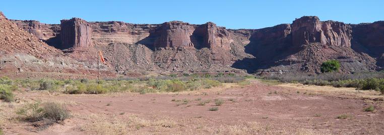
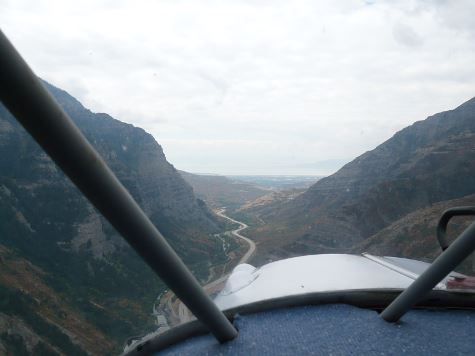
I got shuttled back to the airport early the next morning, and took off for Utah. The Durango airport is at 6689 feet, but I immediately had to climb more to get over the foot hills of the San Juan Mountains. I stopped first at the new Monticello, UT airport (elevation 6966) to fill up my water jug, then headed across the canyon lands to the San Rafael Rise, where I circled over the Robber’s Roost outlaw hideout before landing on the long gravel airstrip on nearby Angel Point.
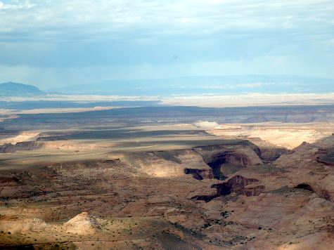
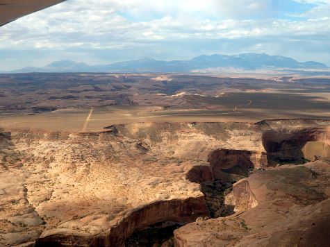
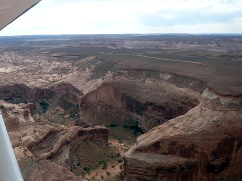
I parked by the intersection of the two runways and pitched my tent. I hiked to the south end of the shorter 2000 foot runway which ended at the edge of the mesa with a 100 foot cliff. Then I turned around and hiked north to the cliff in that direction. And that was about the limits to where I could hike. The south wind came up, so I spent the rest of the afternoon huddled in the tent with my feet braced against the side to keep it from blowing away. Blowing sand got into everything. This wasn’t a great place to camp. In the morning I took off south on the short runway, catapulted over the edge of the mesa, and headed for Escalante, UT. It took two hours to fly the 75 miles. But the upside was that there was a pilot lounge with a couch to sleep on and a shower so I could wash the sand out my hair. The RAF has done some fine work here. In addition to the lounge, there was a picnic shelter with a gas grill and a fire ring.

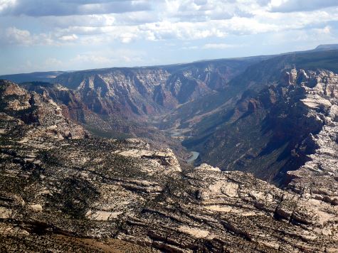
The next day I went back northeast, back over Capitol Reef National Monument, and passed just north of Hanksville and the town of Green River. That’s where I picked up the Green River and followed it northward through Desperation Canyon.

Upon emerging from the other side, I landed at Vernal, UT for gas and a light snack. The purpose of this northerly excursion was to fly over the other two outlaw hideouts, so I continued over Dinosaur National Monument, where the Green River flows through the middle of a mountain, on to the Gates of Lodore, a narrow gorge. Then I was over Brown’s Hole, where there used to be a few ranches. Now it’s known as Brown’s Park, a wildlife refuge. Back in the late 1800’s it was a refuge for the Wild Bunch.
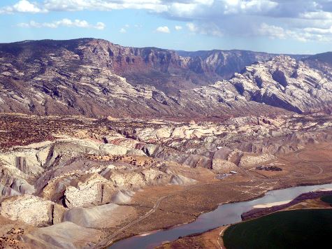

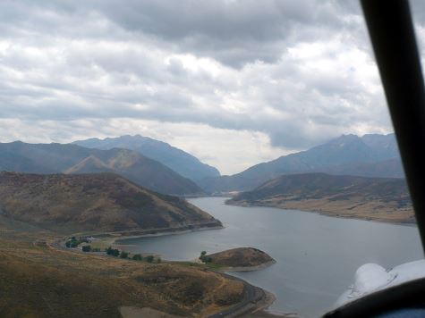
Further up the river is the Flaming Gorge Reservoir where I landed in gusty wind on the abandoned sod runway at Dutch John. There was an old hanger being used as the county maintenance garage, but no services of any kind, nor shelter from the wind. Not a good place to camp. I managed to back taxi on the paved runway, turn and take off in to the wind. I bumped along up to Rock Springs. This was the end of the line. Clouds were rolling in. Rock Springs has airline service, so the airport has tight security. It was too far to go to another airport. Since the airport is quite a ways out of town, my only choice was call a motel that had a shuttle, in this case Best Western. A big low over northern Utah was pushing in wind, low clouds, rain showers and thunderstorms.
I gave up on flying further north to the Hole-in-the-Wall hideout. After two nights I took the shuttle back to the airport. I flew low, under the overcast, west along Interstate 70 as far as Echo, WY, where I took the valley to the south to Heber Valley, UT. This is resort area with ski slopes, chalets and such. I parked at the extremity of the ramp so’s not to be blown away by the executive jets.

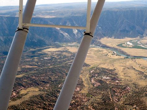
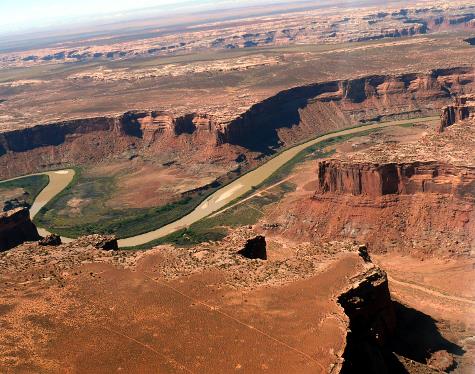
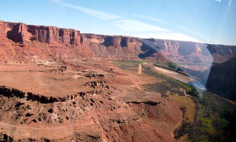
After topping off the wing tanks with $6.44 per gallon gas, I continued south, out Provo Canyon, then hung a left over Soldier Pass, back into desert country. The airport at the town of Green River seemed awful quiet, so I landed there for a final gas stop before heading into the canyon lands. It was quiet for a reason; there was no gas or services of any kind. There was nothing to do but proceed to Canyonlands Airport and sequence in between the two jump planes that operate all day long. I don’t know where all the jumpers come from; it’s a long way down to Moab, the nearest town. Anyway I got my gas and some water and headed twenty miles south to Mineral Canyon. It was easy to find, as it shows on the sectional chart. It’s a 2000 foot deserted mining strip, down next to the Green River at 3900’ ASL. As I approached, I saw a plane taking off to the south, so I dropped down into the canyon and went straight in to the south. This was a mistake, as I had a slight tail wind, and I should have realized that landing downstream, the runway would be slightly downhill. As a result I ended up using whole runway. It was a lovely runway; hard packed clay.
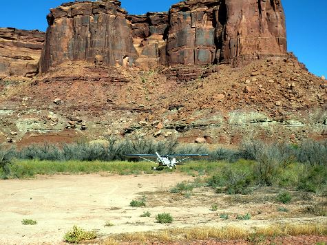
I parked my plane off the side of the runway amongst the mesquite bushes, and found a shady spot across the runway to set up my tent. I hiked for a ways down the canyon, then came back and cooked up supper. I brewed up a cup of tea, and sat back munching chocolate chip cookies. Life is good! It had been a long day. The day is short down in the canyon. I hit the sack early. It was very quiet.
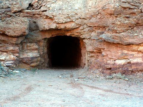
In the morning after breakfast, I hiked up the canyon to discover two abandoned mine shafts up on a ledge in the canyon wall. I hiked back to camp to get my flashlight, and returned to explore inside. The main tunnel had a nice, flat floor, and would be wide enough for a four-wheeler. The main tunnel went in a long ways. There a lot of side tunnels and lot of places where the ceiling had started to collapse. The thought of earth quakes crossed my mind. I didn’t linger.

I was about out of water, so there was no point in hanging around. I packed up camp. I took off to the north, as I was heading back up to the Canyonlands Airport for more water. I guess it would have been better to take off to the south, since the canyon opens up pretty wide in that direction, but either way I would have to make a sharp right-hand turn to avoid smacking into the canyon wall. Being hot and heavy, my rate of climb was around 200 fpm, so I had to fly a couple of miles between the canyon walls before I could get up over the rim. I had to pay attention, and stay over the river, and not stray into any side canyons, or I could have found myself in serious difficulty.
Back at the airport, I filled all my water containers, then headed back south in search of more airstrips. The float wire in my nose tank looked low, so I dumped a wing tank into the nose. Well I overfilled it, and gas came pouring into the cockpit. I hate it when I do that. This is the second time on this trip that I’ve done that. Now I wasn’t sure just how much gas I had, so I turned around and flew the ten miles back to the airport to refill a wing tank (6 gallons). OK back south over the canyon lands. Eventually I spotted a deserted strip on top of a mesa that didn’t look like it had been used in a very long time. Just beyond that I came to the Happy Canyon airstrip. It was situated on a plateau above canyon bottom, with no shade or shelter from the wind, so I didn’t land. Instead I flew back across the Canyonlands to Monticello where I camped in the lounge for the night.
The next morning was Saturday. I had been in touch by cell phone with Mark back in Durango. He had determined that the long range forecast favored departure for home on Monday. I headed back to Durango. It’s good that I got that last bit of gas back at Canyonlands, as I had just enough to get to Durango. Monticello was a new airport, and they hadn’t put their fuel tanks into operation, yet. It was only about an hour to Durango. As I came over the last ridge, I found the valley full of smoke from a controlled burn up in the forest somewhere. I also heard from the radio chatter that the airport was due to be closed at 9am for an air show. I got in twenty minutes before that happened.
It was good to have two days to not be in motion, and get caught up on laundry, home cooking and hot shower. I also had an opportunity to help Mark’s son building his new house as small compensation for the hospitality. Mark and I got off at first light Monday morning, and retraced our route west: Midvalley, over the pass to Santa Rosa, Pampa and Clinton. We helped ourselves to a courtesy car, and went back to Days Inn for the night. Tuesday the forecast was for high 90’s in Oklahoma, so we made tracks for Bartlesville, Lebanon and Centralia. Centralia was not a suitable place to camp, so I suggested we push on the next small airport we came to, which was Flora, Il. I landed on the lovely grass runway instead of the paved one. There were picnic tables on the ramp for our cooking needs, and two couches in the unlocked lounge for us to sleep on; nice! Next day it was on to Connersville IN, Delaware OH, ending up back at Barber Field for another night in the chapter clubhouse. Thursday, October 22, we stopped at St. Marys PA, and I continued on to Glens Falls, while Mark stopped at Norwich NY along the way. After Glens Falls we separated over New Hampshire. Mark flew home and I returned to Norridgewock, arriving around 5pm. It rained the next day.
Conclusions: Tach time was 66.8 hours, but actual flying time was more because I only run the throttle at 2100-2200 rpm. My engine leaks oil a lot; I went through 13 quarts. I spent about $2000, but I don’t know yet what the bill for damage will be. The plane is scared and covered with dirt and oil, but it’s a flier, not a show plane. I was amazed that all the airport bums along the way came out to admire it, “What year is it? I used to fly one of those.” The people of Oklahoma are the finest kind, especially Clinton. It seemed like half the airports we stopped at had executive jets parked on the ramp. I really felt out of place without my Citation Mark X. I wish I was back in Utah; there’s so much to explore.
